
Practical info
Location
Ecole polytechnique
Route de Saclay
91128 Palaiseau Cedex, France
Tél. : +33 (0)1 69 33 33 33
www.polytechnique.edu
GPS coordinates
Visitor parking: 48.713971, 2.214638
Court of ceremonies: 48.714841, 2.210528
General map of the polytechnic campus

Polytechnique Campus Application
Available on Android and iOS, the IP Paris Campus app offers guidance across the campus with Mapwize (a guidance system based on QR code labels).
Access using public transport
2 itineraries from the RER B stations are possible:
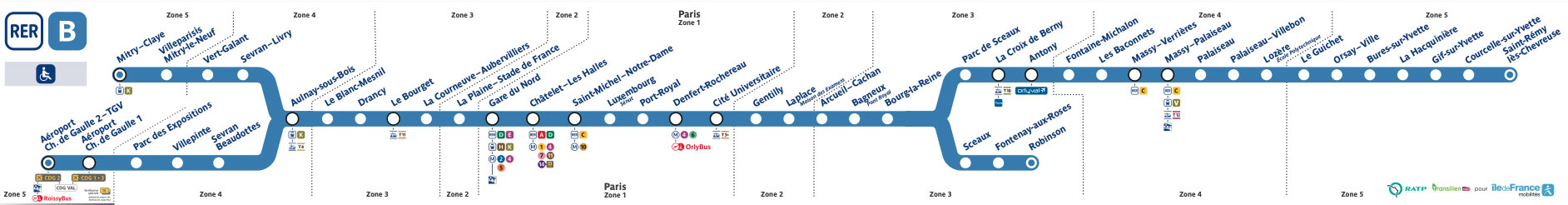
From RER B Massy-Palaiseau station
At the station, take the Bus 4606 or 5154
Get off at: the “ENSTA – Les Joncherettes”.
")
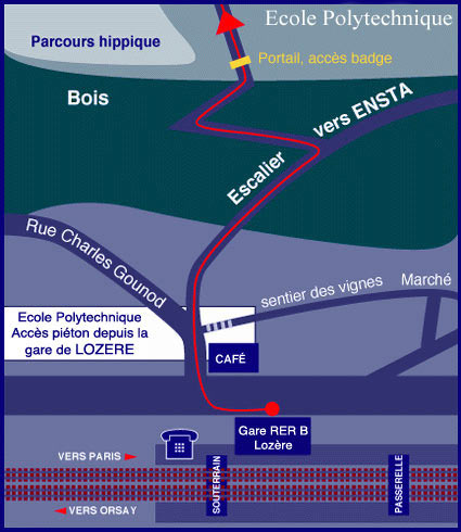
From RER B Lozère station
Pedestrian route with a good 20-minute walk (approx. 300 steps).
Access by road
From the Porte d’Orléans or Porte d’Italie: by the A6 highway.
From the Pont de Sèvres : by the N118.
Consult the traffic status in real time.
Local airports
Orly airport
Take :
OrlyVal | Frequency 5 to 7 min, 6 min ride, stop RER B station “Antony” then take the RER B (see public transportation above) or
Bus 5154 | Frequency : 30 min peak-hours & 1h off-peak-hours
1h10 min trip, Stop “Ensta les Joncherettes”
Roissy-Charles de Gaulle airport
Direct by the RER B destination « Saint Rémy les Chevreuse »
Accommodation
Altough all participants are expected to make their own travel and hotel arrangements, the JCO 2025 Organizing Committee suggests using the plateform Revolugo to book an hotel at privileged rates.